
Lochnagar Crater: The 1 July 1916 Mine, Tunnellers and the Somme Battlefield
↓ Jump straight to planning a private Somme battlefield tour
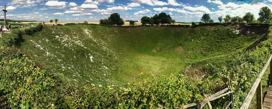
Lochnagar Crater at La Boisselle is one of the largest surviving mine craters of the First World War and one of the clearest physical scars of the opening day of the Somme. At 7:28 a.m. on 1 July 1916, two underground charges containing a combined 60,000 pounds, or 27.2 tonnes, of ammonal exploded beneath the German position known to the British as Lochnagar. The blast created a crater roughly 100 metres across and more than 20 metres deep.
The crater is dramatic, but its historical importance lies underground. British tunnellers had driven a gallery more than 300 metres through chalk beneath no-man's-land. The mine was intended to destroy part of the German line immediately before infantry attacked. It succeeded in demolishing local defences, but it did not create the wider breakthrough expected on the first day. Visiting Lochnagar therefore offers a perfect lesson in both the ingenuity and the limits of mining warfare.
- Explosion time: 7:28 a.m., 1 July 1916
- Explosive charge: 60,000 lb / 27,216 kg of ammonal in two chambers
- Charge depth: About 52 ft / 16 m below the surface
- Tunnel length: About 1,030 ft / 314 m
- Original crater dimensions: About 330 ft / 100.5 m across and 70 ft / 21 m deep
- Location: Near La Boisselle, south-east of Albert
- Purpose: Destroy German positions immediately before the Somme infantry assault
Why armies went underground
Trench warfare made direct assault difficult. Defenders could shelter behind wire and machine guns while artillery struggled to destroy deep positions. Mining offered another option: attack the enemy from below.
Tunnellers dug galleries under no-man's-land, placed explosives beneath enemy trenches and fired them at a chosen moment. The explosion could destroy strongpoints, kill defenders and create a crater that attacking infantry might use as cover.
Mining around La Boisselle
The La Boisselle sector had seen underground warfare well before July 1916. British and German miners fought a hidden contest beneath the front, detonating smaller charges and counter-mines.
The ground around the village became pitted with mine craters. Lochnagar was the largest charge prepared in this sector for the opening of the Somme offensive.
Who dug the Lochnagar mine?
Royal Engineers tunnelling companies carried out the work. The gallery was driven through chalk toward the German line while efforts were made to conceal sound and spoil.
The Lochnagar Crater Foundation records a tunnel length of about 1,030 feet, or 314 metres. This was an extraordinary distance to excavate underground in wartime conditions.
Clay kicking versus chalk mining
Visitors familiar with Messines may have heard of quiet clay-kicking techniques in Flanders. Lochnagar involved chalk geology, which required different excavation methods.
Geology influenced how quickly tunnels could be driven, how they were supported and how much noise they created. Military mining was as much an engineering problem as an infantry support tactic.
How the charge was arranged
The 60,000-pound ammonal charge was divided between two chambers about 60 feet apart. Both were placed roughly 52 feet below the surface.
Splitting the explosive helped destroy a larger section of the German position when the charges fired together.
7:28 a.m.
The mine was detonated two minutes before the main infantry assault. Captain James Young operated the firing system.
A massive column of chalk, earth and debris rose above the battlefield. The explosion destroyed a section of the German line and several underground shelters.
Why two minutes mattered
The timing was intended to minimize the interval between the explosion and the infantry attack. If the mine was fired too early, surviving German troops could recover and occupy the crater rim.
If fired too late, British troops risked being caught by falling debris or the blast itself. Mine timing therefore had to be integrated into the artillery and infantry plan.
The mine at Hawthorn Ridge was fired earlier
At Beaumont-Hamel, the Hawthorn Ridge mine exploded at 7:20 a.m., ten minutes before the main attack. That early detonation has often been criticized for giving German defenders time to prepare.
Comparing Hawthorn and Lochnagar shows that mines were not simply spectacular explosions. Their tactical value depended heavily on timing and exploitation.
How big was the crater?
The Lochnagar Crater Foundation gives original dimensions of about 330 feet, or 100.5 metres, across and 70 feet, or 21 metres, deep. A lip of displaced material rose several metres above the surrounding ground.
Modern measurements vary slightly because the sides have eroded over more than a century. Visitors should expect a huge bowl rather than a perfectly preserved 1916 profile.
Was Lochnagar the biggest mine of the war?
The foundation describes Lochnagar as the largest crater created by a single aggressive explosion and one of the most impressive mine craters created in war. Other First World War mines used larger explosive charges, including at Messines in 1917, but geology and charge placement produced different crater sizes.
It is therefore safer to be precise than to make a universal “biggest explosion ever” claim.
How many Germans were killed?
Exact figures are uncertain. The explosion destroyed German trenches and dugouts, but wartime casualty records cannot provide a precise number attributable only to the mine.
Older accounts sometimes calculate a theoretical total from the capacity of destroyed dugouts. That should not be presented as a confirmed death toll.
The infantry still had to attack
The mine created local destruction, but British infantry still faced surviving positions on both sides. German machine guns outside the blast zone could fire across the crater and surrounding ground.
This is the core lesson of Lochnagar. Engineering could break one section of a defensive system. It could not eliminate the entire front.
The 34th Division
British troops of the 34th Division attacked in the La Boisselle sector on 1 July. The division included the famous Tyneside Scottish and Tyneside Irish brigades.
Their advance across long open approaches produced severe losses. The crater should therefore be connected with the wider infantry battlefield rather than treated as a separate mining monument.
Sausage Valley and Mash Valley
The ground around La Boisselle contains valleys that channelled attacking troops. Sausage Valley lay south of the village and Mash Valley to the north-west.
German positions on higher ground could fire into these approaches. Standing at Lochnagar and orienting toward the valleys helps explain why the attack was so costly.
La Boisselle village
The village itself became a fortified obstacle and was not secured immediately on 1 July. Fighting continued after the opening attack.
The rebuilt modern village hides most physical evidence, making Lochnagar even more valuable as a surviving landscape feature.
The Glory Hole
Nearby ground known as the Glory Hole was intensely mined before the Somme offensive. A dense network of underground galleries and craters developed between the opposing lines.
The area demonstrates that Lochnagar was not an isolated mining project but part of a long underground war beneath La Boisselle.
What happened to the crater after 1916?
Unlike many smaller battlefield craters, Lochnagar was not filled and returned to agriculture. It remained visible after the war.
Over time vegetation covered the sides, erosion softened the rim and the site became part of the Somme remembrance landscape.
Richard Dunning and preservation
In 1978 British businessman Richard Dunning purchased the crater to prevent development and preserve it as a memorial. The Lochnagar Crater Foundation now maintains the site.
This private preservation story is important. Battlefield heritage survives because individuals, governments and organizations make choices about land after the war.
The memorial cross
A large cross stands at the crater. Wreaths and personal tributes are often placed nearby.
The site has developed from a surviving piece of military engineering into a place of remembrance for all who fought on the Somme.
The annual 1 July ceremony
Commemorative ceremonies take place at Lochnagar around the anniversary of the Somme's opening day. The crater attracts visitors from Britain, France and Commonwealth countries.
If visiting around 1 July, expect larger crowds and altered access arrangements.
Do not climb into the crater
The crater sides are steep and unstable. Visitors should remain on the designated path around the rim.
Battlefield ground may also contain unexploded ammunition and buried debris. Preserving the site means not treating it as an adventure playground.
What can be seen from the rim?
The surrounding farmland is as important as the crater. Look toward La Boisselle, the Albert-Bapaume road and the valleys used by attacking troops.
The crater becomes more historically useful when it is located within the wider first-day battlefield.
Lochnagar and Thiepval
Thiepval explains the missing and the German ridge system farther north. Lochnagar explains British engineering preparation before the attack.
Visiting both shows two completely different ways the Somme is remembered: one through a post-war architectural memorial, the other through a preserved wound in the ground.
Lochnagar and Pozières
Pozières lies only a short drive north-east. The chronological link is useful. Lochnagar belongs to 1 July; Pozières shows how the offensive continued later in July and August with major Australian involvement.
The two sites together prevent the Somme story from ending on the opening morning.
How long to spend
Allow around 30 minutes for a normal visit. More time is worthwhile if discussing tunnelling techniques, the 34th Division and the La Boisselle battlefield.
Walking the complete rim gives a better sense of scale than viewing the crater from the entrance alone.
Myths to avoid
Do not present an exact German death toll from the explosion as certain. Do not rely on stories that the blast was definitely heard in southern England without qualification. Large explosions produced reports over great distances, but spectacular claims are often repeated more confidently than the evidence supports.
The verified engineering figures are impressive enough on their own.
Why Lochnagar matters
The crater makes underground warfare visible. Most mine galleries are inaccessible and invisible; Lochnagar shows the physical consequence of one.
It also demonstrates the central paradox of the first day. Enormous preparation and technical skill could produce a spectacular local result without solving the wider tactical problem.
What happened in the seconds after the explosion?
The blast did not create an empty battlefield. Debris fell back across the position, dust reduced visibility and surviving German troops nearby tried to understand what had happened. British infantry then had to move through a landscape that had just been violently reshaped. The crater itself could help and hinder at the same time: its lip offered some cover, but it also disrupted the planned route of advance and created a conspicuous landmark under enemy observation.
This is why mine warfare has to be understood as part of a combined plan. A mine could destroy a trench section, but the attacking infantry still needed clear routes, artillery support, communication and enough momentum to exploit the damage before defenders recovered.
Why mine craters could become defensive positions
Once an explosion created a crater, both armies immediately understood its tactical value. The near and far lips could provide cover, observation and firing positions. On other sectors of the Western Front, armies fought repeatedly for possession of newly formed craters.
At Lochnagar the scale of the blast made the crater an extraordinary feature, but the principle was the same. Destruction created new terrain, and that terrain immediately became part of the battle.
The men underground were fighting a different war
Tunnellers rarely experienced combat in the same way as front-line infantry. Their danger came from collapse, bad air, enemy counter-mines and the possibility of being buried alive. Their work was technical, repetitive and mentally exhausting. Progress could be measured in metres rather than in captured trenches.
Because their galleries had to remain secret, much of their achievement was invisible to the infantry they supported. On 1 July, months of underground labour became visible in a few seconds. The crater is therefore also a memorial to a form of warfare that usually left very little above-ground evidence.
How Lochnagar compares with the Messines mines
Visitors who have already seen Hill 60 or the Pool of Peace in Belgium can use Lochnagar as a comparison. The Somme mine was fired in July 1916 as part of an attack that failed badly across much of the British front. The Messines mines were fired in June 1917 within a much more tightly integrated operation that captured the ridge.
The comparison shows tactical development. Mining remained important, but the decisive difference was how the explosions were coordinated with artillery, infantry objectives, consolidation and the wider battle plan.
Why Lochnagar survives when so many craters disappeared
After the war French farmers faced a practical problem: they needed to return devastated fields to production. Smaller shell holes and mine craters were often filled, levelled or gradually absorbed into farmland. Large features could also be altered if they interfered with cultivation.
Lochnagar's exceptional size made complete removal difficult, but survival was still not guaranteed. Later private preservation ensured that the crater would remain a dedicated memorial rather than be treated only as inconvenient damaged ground.
The crater as a teaching site
Lochnagar works especially well with school groups or first-time battlefield visitors because the physical evidence is immediately understandable. Visitors do not need a trench map to recognize that something enormous happened here. The guide's task is then to turn that visual impact into explanation.
The most useful questions are simple: how did the tunnel reach this point, why was the charge here, what German position stood above it, and what did the British infantry have to do next? Those questions move the visitor from spectacle to military history.
Family-history links around La Boisselle
If a relative served with the 34th Division, Tyneside Scottish, Tyneside Irish or another unit in the La Boisselle sector, the crater can anchor a much more personal battlefield visit. War diaries and trench maps can show whether a battalion passed south or north of the crater, which valley it crossed and what objective it had on 1 July.
This is especially useful for soldiers with no known grave. Even when there is no headstone to visit, the terrain can often narrow a man's final battlefield to a very specific part of the Somme.
Guide's perspective: do not begin by telling visitors how large the crater is. Begin by pointing to the German line and explaining that men dug more than 300 metres underground to place explosives beneath it. Then walk to the rim. The scale has a reason.
Frequently asked questions
When did the Lochnagar mine explode?
At 7:28 a.m. on 1 July 1916, two minutes before the main British infantry assault on the Somme.
How much explosive was used?
The Lochnagar Crater Foundation records 60,000 pounds, or about 27.2 tonnes, of ammonal divided between two chambers.
How large is Lochnagar Crater?
The original crater was about 330 feet, or 100.5 metres, across and roughly 70 feet, or 21 metres, deep. Erosion has changed the exact modern profile.
How long was the mine tunnel?
About 1,030 feet, or 314 metres.
Can you walk into Lochnagar Crater?
No. Visitors should remain on the designated rim path because the sides are steep and the battlefield must be protected.
How long should I spend there?
Around 30 minutes is enough for a normal visit. Allow longer if you want to study the La Boisselle mining and first-day battlefield in detail.

Private Somme & Northern France Battlefield Tour
Connect the crater with La Boisselle, the first-day infantry attack, Thiepval and Pozières so the mine becomes part of the full Somme story rather than a stand-alone photo stop.
Private full-day tour for your group. Current seasonal price and availability are shown on the tour page.
Check AvailabilityWritten by Niels Declercq, private WW1 battlefield guide based in Bruges.